For the Crater Good
Mentors: Aleksandra Gawronska (Catholic University) and Barbara Cohen (NASA GSFC)
Keywords: lunar volcanism, lunar outgassing, impact cratering, remote sensing, GIS
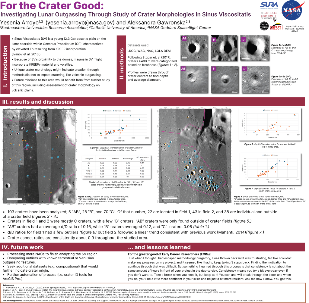
Because the Moon lacks the mechanisms typically required to form silicic domes, understanding this region has significant implications for lunar volcanology and crustal evolution. Due to my extensive experience in terrestrial volcanology and fieldwork, I made substantial contributions to the design and revision of this study, which taught me to view iteration as a form of progress and reinforced my ability to conduct independent research. This project also provided me with the opportunity to learn how to use the US Geological Survey (USGS) Integrated Software for Imagers and Spectrometers (ISIS) and Esri’s ArcGIS Pro. As a result, I led the analysis of crater morphologies across Sinus Viscositatis using remote datasets collected by instruments onboard spacecraft, such as the Lunar Reconnaissance Orbiter, to identify anomalies that might indicate volcanic outgassing rather than impact. I am currently writing a first-author publication summarizing our study of the Sinus Viscositatis region. More than anything, this project affirmed to me that I am capable of conducting original research and deepened my commitment to studying the Moon’s geologic history and the broader processes that shape planetary bodies.
GEO-REPS
Mentors: Lis Gallant (UH Hilo) and Kellie Wall (USGS CVO)
keywords: monogenetic volcanism, ground penetrating radar, petrography, fieldwork
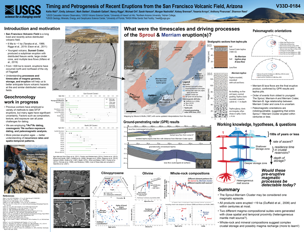
Through the NSF GEO-REPS program, I joined a team of scientists from the Cascades and Hawaii Volcano Observatories (CVO and HVO, respectively) to conduct research in the San Francisco Volcanic Field (SFVF) in Arizona in May 2023. Our goal was to constrain the age of several overlapping lava flows at Merriam Crater and the Sproul spatter rampart using paleomagnetism, sample collection, and ground-penetrating radar (GPR). As part of the GPR team, I helped collect subsurface data that revealed a previously unrecognized buried lava flow. I later visited CVO to analyze thin sections of the collected samples using petrographic and scanning electron microscopy techniques to identify any unusual occurrences, such as a specific clinopyroxene xenocryst with a core and crust of different compositions.
These findings, presented at the AGU 2023 and GSA 2024 annual meetings, helped the team determine that the lava flow damming the Little Colorado River originated from the Sproul, not Merriam Crater. Witnessing the project evolve—from site selection to sample analysis—was an invaluable lesson in how iterative and collaborative the research process can be. I enjoyed learning how to take field notes on-site and to select samples, including tips on recreating the order in which multiple flows might have erupted by examining evidence and other markers near volcanic vents, as well as the ways different tools can be used to collect and process data from a single site.
GeoSPACE
Mentors: Anita Marshall (UF) and Trevor Collins (Open University)
Keywords: geoscience education, volcanology, fieldwork
After graduation, I fully committed to geoscience research, first by becoming a research assistant for the GeoScientists Promoting Accessible Collaborative Experiences (GeoSPACE) project, a field program that reshaped my understanding of the relationship between inclusion and scientific innovation and reframed how I viewed fieldwork and accessibility. GeoSPACE also introduced me to volcanology, reigniting my dream of studying planetary surfaces and leading me to pursue a path that merges research, communication, and inclusion.
Following the first successful run of GeoSPACE, PI Dr. Anita Marshall, Co-I Dr. Lis Gallant, and I submitted an application for additional funding. We were awarded the NSF Geoscience Research Experiences for Post-Baccalaureate Students (GEO-REPS) supplemental funding opportunity, which enabled me to transition into a Program Manager role for the course. For the second year, we aimed to introduce new fieldwork sites, so I assisted with site selection. Site selection taught me that field science isn’t just about asking the right research questions but about anticipating who might be excluded by our choices and designing studies that work for everyone. It also enabled me to determine whether the locations were on Bureau of Land Management (BLM) land or private property, which helped me understand the permitting and access process —an essential first step in any fieldwork campaign.
My undergraduate coursework primarily focused on aquifers and karst topography, which are characteristic of Florida’s landscape. I had never seen a mountain until traveling to Idaho for an EarthScope Consortium Geophysics Tools for Societal Issues (GETSI) course on Structure from Motion (SfM), where we used drone imagery to create point clouds and digital terrain models. This experience revealed how technology can make field science more inclusive, a lesson I reinforced when teaching GeoSPACE participants to use real-time kinematic (RTK) equipment and photogrammetry software. For its innovation in accessible geoscience education, the GeoSPACE team received the 2025 American Geophysical Union (AGU) Excellence in Earth and Space Science Education Award, an honor that affirmed the value of inclusion as a driving force in scientific progress.
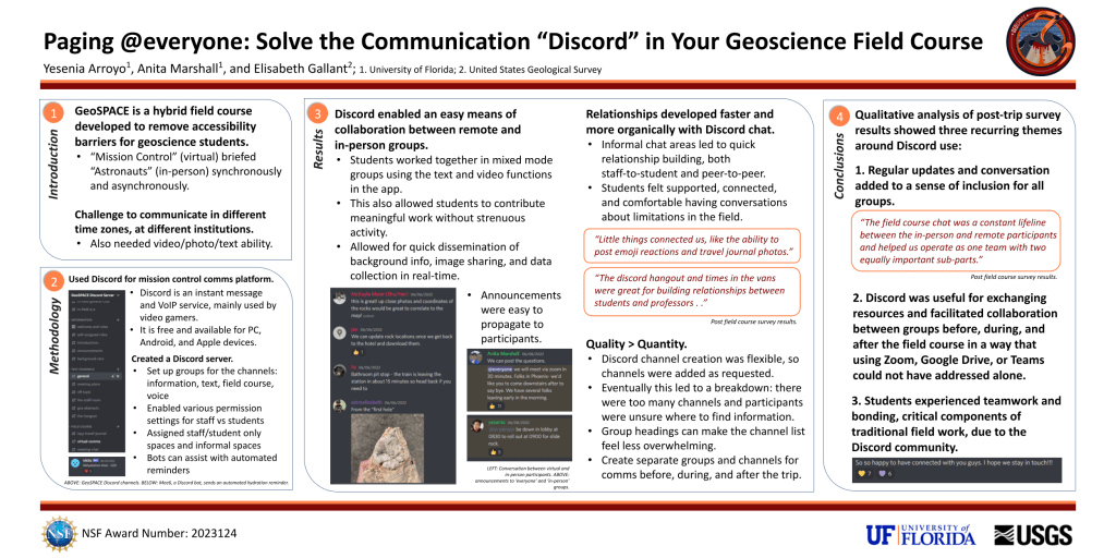
My work with GeoSPACE also included technology management, where I collaborated with Dr. Trevor Collins on the impacts of video streaming and the utilization of modern communication methods on student engagement. As someone who grew up online and with instant messaging, I was excited to conceptualize the use of a social media platform (Discord) in educational field settings, a strategy that is now being emulated by other field programs. We evaluated outcomes through thematic analysis and found that the approach can enable strong bonds across virtual and in-person teams, fostering a sense of community. This culminated in my first scientific poster, presented at the 2022 GSA annual meeting, which explored how digital tools can create equitable field experiences. I am currently writing a first-author paper centered on how using Discord helps establish and maintain relationships similar to those found in other communities of learning, thereby contributing to the development of a geoscience identity in students.